Ride report - August 2004
Northern CA and Oregon coast, central Oregon
Day 3 - Charleston to Portland
 I saddle
up and roll at 0730 on a foggy, wet morning. Smells great. First thing
I head southwest to have a look at Sunset Bay State Park, a favorite stop
on family camping trips when the kids were smaller. And on to Shore Acres,
a timber baron's mansion on the cliffs. It's closed at this hour. But it's
a nice side trip, riding alone through the tunnel of dripping trees, fog
ahead and behind.
I saddle
up and roll at 0730 on a foggy, wet morning. Smells great. First thing
I head southwest to have a look at Sunset Bay State Park, a favorite stop
on family camping trips when the kids were smaller. And on to Shore Acres,
a timber baron's mansion on the cliffs. It's closed at this hour. But it's
a nice side trip, riding alone through the tunnel of dripping trees, fog
ahead and behind.
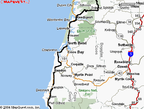
Back to 101 for an Egg McMuffin, then up to Reedsport.
I have a scheme to get off 101...
 Just
north of the bridge at Reedsport I turn up the Smith River. Immediately
the fog disappears and I'm riding a well-paved twisty road along the river.
This is more like it. Sunshine, shadows from the birch trees, a couple
of deer. This is why I wanted to ride in Oregon.
Just
north of the bridge at Reedsport I turn up the Smith River. Immediately
the fog disappears and I'm riding a well-paved twisty road along the river.
This is more like it. Sunshine, shadows from the birch trees, a couple
of deer. This is why I wanted to ride in Oregon.
I'm beginning to realize I can't trust the map, though. Some roads just
don't appear where the map shows them, others aren't on the map. No matter
- you're not really lost if you have gas in the tank. I stop at a campground
beyond Sulphur Springs to get some hints and all of the adults (6 of them)
in the group are lost to some degree or other. But they wish me good luck.
The road junctions all have Forest Service signs, but most of them mean
nothing to me. I continue generally northwards, I think, as the road gets
narrower and rougher. Finally it's down to a one lane gravel track - oddly,
this gravel section is only about a mile long on both sides of a ridge.
Then the pavement picks up again. It's like it was built from both ends
and they couldn't agree on who had to do the hilltop.
Mostly downhill now, the road getting better, as I approach highway
126 and Mapleton. 126 from Eugene to Florence would be a nice road except
for the traffic. Enough of it. At Mapleton I turn back on 36 to Swisshome
and north on Indian River Road. Twelve miles of well-paved country road
suddenly changes to single track gravel - with no signposts. Well, I still
have gas so I'm not lost. Up the hill on the increasingly steep gravel
road which eventually seems to stay on the ridgeline. After an hour or
so of gravel road, I find a paved one so I take it. Left, I guess, would
be towards the coast. But I soon realize that the sun is in my face, not
at my back.
I have a compass in my riding bag, but it wouldn't make much difference
- I know the direction I want to go, but the road isn't
taking me there. Another couple of miles and there's a junction with signposts!
Ah. Great time to stop for lunch. (I always carry emergency rations when
I'm exploring.) As I munch I study the signposts: Hwy. 34, 17 miles; Hwy
36, 18 miles; Hwy 101, 26 miles.
OK, I wanted to go north to 34 and west to the coast. But the road
to 34 is the one I just came from. I'm 17 miles from it now, I guess I
was about 12 miles from it when I left the gravel. But I'm not lost.
Enough. I'll try the road to 101. It's paved, sort of, but badly torn
up by log trucks and heavy equipment. There's lots of logging around here.
About 45 minutes later I have a stop sign. It's the road up the cliff to
Cape Perpetua above 101.
It's been fun, but time to carry on up the road. I've bypassed 40 miles
of 101 up the coast and I've covered 126 miles. Time for some gas!
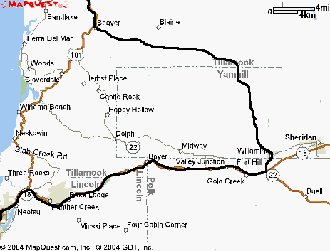 Another
40 miles or so up 101 and I find Lincoln City, where I turn inland on 18
towards Willamina and a visit with my mother- and sister-in-law. This has
never been a favorite stretch - the road is pleasant but the traffic is
heavy. The radar detector passes several tests along here - nice, because
I don't screw around when I pass cars on a two-lane road. The bicycle speedo
on the SV shows a top speed of 97 at the next gas stop, when nearly all
the roads in Oregon have a 55 limit.
Another
40 miles or so up 101 and I find Lincoln City, where I turn inland on 18
towards Willamina and a visit with my mother- and sister-in-law. This has
never been a favorite stretch - the road is pleasant but the traffic is
heavy. The radar detector passes several tests along here - nice, because
I don't screw around when I pass cars on a two-lane road. The bicycle speedo
on the SV shows a top speed of 97 at the next gas stop, when nearly all
the roads in Oregon have a 55 limit.
It's very considerate of the State Police to operate their radar full-time
- it gives lots of warning. I'll have to write and thank them.
It's only about 25 miles to Willamina, then I head north, 11 miles up
the hill, for a quick visit.
Then on up Gilbert Creek Road and over the hill and back down. Very
twisty, well paved, remote. Nice ride. At the bottom of the hill I pick
up the somewhat wider (but still very nice) road from Carlton towards
101 at Beaver. This is 5 or 6 miles inland from the coast.
Up 101 (much nicer here, less traffic) to Tillamook and a gas stop.
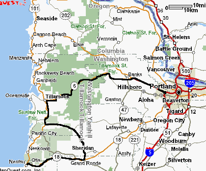 I'm
heading for west Portland (Beaverton) for the night. Hwy 6 from Tillamook
is a pleasant surprise - beautiful road, moderate traffic, regular passing
lanes. Another thing I like about Oregon is they use the double-yellow
line much more sparingly than California, so you can pass legally on a
regular basis. I've often felt Caltrans' attitude towards passing is "screw
'em".
I'm
heading for west Portland (Beaverton) for the night. Hwy 6 from Tillamook
is a pleasant surprise - beautiful road, moderate traffic, regular passing
lanes. Another thing I like about Oregon is they use the double-yellow
line much more sparingly than California, so you can pass legally on a
regular basis. I've often felt Caltrans' attitude towards passing is "screw
'em".
After a pleasant - and fast - ride up 6, I pick up 26 and it's freeway
into Beaverton.
Amazing: from the hills above Willamina to the first Beaverton exit
was exactly two hours. Going out to the coast and back in is faster than
the inland route to Portland and a whole lot nicer.
I don't have motel reservations so I ride around Beaverton in 90F temperatures
during rush hour looking for a place. Settled on a Shilo Inn which turned
out to be a mixed bag - good condition, clean, terrible TV reception (I
wanted to watch the baseball game). The restaurant had excellent food and
terrible service - only one waitress for the restaurant and bar. Really
good food, though.
I'm gonna take a day off tomorrow.
index day
1 day 2 day
3 day 4 day
5 day 6 day
7